
Encyclopedia | Library | Reference | Teaching | General | Links | About ORB | HOME
 Introduction to the history of medieval
boroughs
Introduction to the history of medieval
boroughs
|
Introduction menu Problems of definition | Continuity or creation? | Wiks, burhs, and ports PLANNED/PLANTED TOWNS | Growth of self-government | Urban economy | Urban society further reading |
| Origins: planned / planted towns |
 |
|
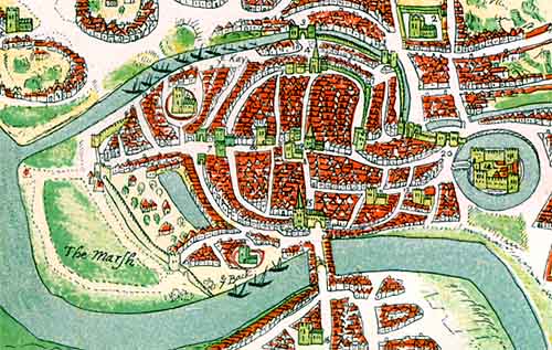
(above) Detail from William Smith's view of Bristol, 1568. Bristol was a flourishing port with a mint at the beginning of the 11th century, but its origins and measure of planning that may have gone into its layout are still uncertain. Impetus to settle there came from the protective and commercial benefits of the Rivers Avon (south) and Frome (a tributary). Early settlement lay on raised ground between these two; it was much smaller than in this depiction, a defensive bank defining its perimeter – still visible in 1568 in the almost circular course of the inner ring road – later replaced by a wall. The north-south road between bridges across the two rivers, and a cross-cutting east-west road were the original foci for habitation, their names – respectively Broad Street/High Street and Corn Street/Wine Street – indicating their importance and the commercial character of the settlement. It was the river crossing which gave Bristol its name, derived from Saxon terms meaning "place of assembly by the bridge". |
|
|
 previous |
 main menu |
 next |
| Created: April 5, 1999. Last update: August 30, 2001 | © Stephen Alsford, 1999-2003 |
|
Encyclopedia | Library | Reference | Teaching | General | Links | Search | About ORB | HOME The contents of ORB are copyright © 2003 Kathryn M. Talarico except as otherwise indicated herein. |
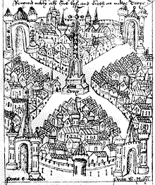 Those core features were what an artist chose to highlight, in an
illustration (at right) for
Those core features were what an artist chose to highlight, in an
illustration (at right) for