
Encyclopedia | Library | Reference | Teaching | General | Links | About ORB | HOME
 Introduction to the history of medieval
boroughs
Introduction to the history of medieval
boroughs
|
Introduction menu Problems of definition | CONTINUITY OR CREATION? | Wiks, burhs, and ports Planned/planted towns | Growth of self-government | Urban economy | Urban society further reading |
| Origins: continuity or creation? |
 |
|
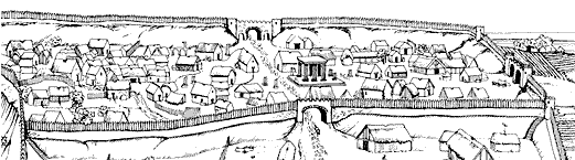
An artist's impression of the core of Lincoln, as it might have looked in the early 11th century. The invading Romans established a base on a ridge to the north of the River Witham, which initially served as a frontier fort in the early phase of their conquest of Britain. Ermine Street, the main north-south route built by the legions, and the Fosse Way, a southwest/northeast route marking the boundary of the Roman advance at that time, converged at Lincoln. As the Romans extended their sway further north, Lincoln transformed from fort to colony and settlement spread beyond the walls towards the river. What happened after the Roman legions left Britain is uncertain, but there is some evidence of continued habitation within Lincoln. The sturdy Roman walls continued to offer protection. It was one of five key places around which the Danish invaders/settlers focused their interests and commercial activities, which helped revitalize the town. The Roman walls (whose route was followed by medieval replacements), their gates, and the roads linking the gates exercised some influence over the layout of the medieval settlement. The Normans later built a castle on the site of the old legionary buildings (southwest corner of the part of the city shown here), while the Norman cathedral close absorbed the site of the Roman temple at the centre of the Roman colony, atop whose foundations a church was built. |
 previous |
 main menu |
 next |
| Created: April 5, 1999. Last update: March 21, 2000 | © Stephen Alsford, 1999-2003 |
|
Encyclopedia | Library | Reference | Teaching | General | Links | Search | About ORB | HOME The contents of ORB are copyright © 2003 Kathryn M. Talarico except as otherwise indicated herein. |