| |
DITCH / BANK
It has been hypothesized from the name of one of the principal roads
through Conesford, Berstrete, together with the
deviation in the curve of the town wall at the southern end of the city
(suggestive of a direction northwards up Berstrete, rather than the actual
more westerly curve taken by the main part of the wall), that a
burh defence may
have at one time existed along the line of this route to protect the
south-western side of Conesford. Archaeology has not substantiated this
(in contrast to evidence of a ditch in the northwestern sector of the
Anglo-Saxon settlement), and it seems unlikely that burh fortifications
would have extended so far south beyond the main concentrations of
settlement, but the theory remains.
As one of the most important, populous and prosperous towns of the
kingdom, it was caught up in national conflicts and was used as a base,
or targeted for attack, by rebels on several occasions between the
Conquest and the baronial revolt of mid-13th century. The civil war
between Stephen and Matilda had prompted the townspeople to devote effort
to ditch-digging in the (formerly unprotected?) area of Westwick, although
such efforts were also motivated by the desire to define boundaries. The
assault by Flemings in 1174 apparently went undefended and the city was
sacked. Each generation must have had occasion to perceive the
vulnerability of the place. A city ditch is again heard of in 1235.
The ditch-bank dug in 1252/53 may have been an extension of existing
defenses or may have followed a new line (in either case, it is generally
assumed to have been that later taken by the
stone walls), enclosing a large area of
about a square mile, and serviced by 9 gates (see below) with wooden
gatehouses. As complaints by the surrounding countryside and by the monks
attest, the line of the new ditch encompassed lands that were sparsely
settled or simply fields (e.g. Gildencroft,
Normannesland, Great Newgate) –
these might have been considered "suburbs" (and parish churches of late
Saxon or early Norman period are associated with those to the north of the
burh-ditch line) but the complaints suggest that some were strictly
speaking outside of the jurisdiction of Norwich proper. However, since
the monks were defending their own
jurisdictional claims, their complaints
cannot entirely be trusted. The new defensive line bulged out well
beyond the lines (actual or hypothetical) of any Anglo-Saxon burh defense,
to incorporate areas not then protected and those of 11th century
expansion – notably Westwyk and Mancroft (now the urban centre) – as
well as unsettled lands, some of which may however have once been borough
fields subsequently lost to encroachments following the Conquest.
Although the course of the ditch was dictated in part by the desire for a
line that did not undulate in a way that would have created defensive
problems, it also represented an assertion – if not a re-assertion – of
territorial claims.
|
| |
| |
INDEPENDENT JURISDICTIONS:
|
| A |
The Cathedral-priory precinct.
The site acquired by Bishop Losinga was unusually large; he envisaged
not only a cathedral but also a priory for
60 Benedictine
monks and an episcopal palace. The eastern section of the site was
meadow, but western parts were previously built on and two churches had to
be demolished; according to the complaint about the 1253 ditch, the
meadowland – known as Cowholm – and the land on which St. Michael's had
stood were not part of the hundred of
Norwich). The Prior's Fee included not only the close proper (east of
Tombland and south of Holmestrete) but also Tombland itself and the settled
area along Holmestrete, as well as Normannesland and Great Newgate (see
below); the townspeople in these areas fell under a jurisdiction separate
from that of the city.
|
|
B |
The Great Hospital.
In 1249, Bishop Suffield founded the Hospital of St. Giles to take care
of priests who were too poor (i.e. lacking a living) or too ill to work;
30 beds were provided for the sick and infirm, while provision was made
for feeding other of the poor there daily. The hospital was endowed with
meadow-land stretching eastwards to the river. Over time it gradually
strayed from its mandate and became a desirable retirement home for
wealthy citizens.
|
|
C |
The Castle Fee.
The size of the fee can be imagined from the fact that 98
burgesses lost their homes when the earthworks were constructed. Even
though it is only the keep and the mound raised beneath it which now
survive, they are still imposing. The extensive
fortification, which
was the single royal castle in Norfolk and Suffolk, must have had a
daunting effect on any remaining Anglo-Saxon ambitions for independence.
When the city took over the Fee in 1345, the keep and its mound were
excluded.
|
|
D |
The Shirehouse.
The location where the county court was held, presided over by the
sheriff. Consequently, this remained outside city juridiction even after
acquisition of the surrounding Fee (1345).
|
|
E |
Normannesland.
An area of land here was part of the Prior's Fee and came to be known
as Spitelond. According to the complainants made about the 1253 ditch,
this area was never actually part of the hundred of Norwich. At the time
that a hospital dedicated to St. Paul (although often known as
Normanspitel) was founded thereon, in the first half of the 12th
century, new endowments extended the area northwards, new settlers were
found, and a new parish church (with the same dedication) provided for
them. The hospital served poor invalids.
|
|
F |
Great Newgate.
This was mainly agricultural land, and was earlier known as
Thedwardscroft. The name "Newgate" was inherited from the street on
which it subsequently lay, which must at some point (probably in the
11th century) have been a new offshoot from Nedham Street. From ca.1100
it was part of the Prior's Fee, remaining agricultural in character but
possibly with some minor settlement of townsmen thereon prior to 1253.
After lengthy disputes between city and priory as to ownership, the king
took it away from the Prior (1291) and handed it over to the city (1305);
this decision may have been motivated more by a consequent increase to the
fee farm than to clear evidence of
ownership.
|
|
H |
Little Newgate.
Fields held by Carrow Abbey, but possibly with some
minor settlement thereon prior to 1253 (when the area was named among
others in the complaint about the ditch). The Abbey held
leet court for its tenants there, but
surrendered its jurisdiction to the city in 1290. The name was inherited
from the area being adjacent to the lower (and lesser) part of the street
known as Newgate.
|
| |
Pockthorpe
The manor of Pockthorpe was part of the Prior's Fee and extended along
the northern bank of the river to where it turned south. It served as a
home farm for the cathedral-priory. After having been truncated by the
line of the 1253 ditch, the area within the ditch was within a century,
acquired by the
Carmelites
for their friary.
|
| |
Carrow
Carrow Abbey was founded in 1146, by grant of the king to some
Benedictine nuns, to the south of the (future) walled area, but on
lands that had earlier served as townsmen's fields, thus setting the
scene for future jurisdictional disputes. One such was the nunnery's
claim to have the right to collect a toll on corn sold in the city during
the time of the Carrow Fair; this too was relinquished in the settlement
of 1290, with the city authorities promising in return not to obstruct
the holding of the fair.
|
| |
Chapel in the Fields
This chapel occupied quite a large site (described as a croft) by mid-13th
century. It originally included a hospital, but shortly before the
1253 ditch was dug, was converted to the collegiate church of
St. Mary's, housing a community of priests. In the 14th century, before
the large Guildhall superseded the small Tolbooth,
this chapel was occasionally used for major civic assemblies.
|
| |
| |
CITY GATES:
|
| G1 |
Conesford (later King Street) Gate. This was the first gate to receive a
mention, in 1186.
|
| G2 |
Berstrete Gate
|
| G3 |
Swinemarket Gate (later the Brazen Doors). This was an entrance/exit of
lesser importance; when the wall was built it was provided only with a
postern gate here.
|
| G4 |
Nedham (later St. Stephen's) Gate. This was the major entrance to
the city from the south. A leper house was later established
a short distance beyond this gate.
|
| G5 |
Newport (later St. Giles) Gate. Named for the street which led here
through the novus portus (new borough) founded for French settlers.
A leper house was later (ca.1343) established immediately outside this gate.
|
| G6 |
Westwyk (later St. Benedict's) Gate. A leper house was later established
immediately outside this gate.
|
| G7 |
Coselanye (later St. Martin's) Gate
|
| G8 |
St. Augustine's Gate. A leper house was later established a few hundred
yards beyond the gate.
|
| G9 |
Fybriggate (later Magdalen) Gate. A leper house was later established
immediately outside this gate.
|
| G10 |
Barregates (later Pockthorpe Gate).
|
| |
| |
OTHER FEATURES:
|
|
I |
Bishop's Bridge. It does not seem that a gate was
erected to protect this entrance into the city until the 1330s, and then
as part of citizen Richard Spynk's
contribution towards the development of defences, even though jurisdiction
over the bridge was a bone of contention between city and priory.
|
|
J |
Gosehill.
An area of unsettled land belonging, according to the complaints about the
1253 ditch, to Carrow Abbey and not part of Norwich hundred – although
the presence of Conesford gate there earlier suggests the townsmen
considered the area part of Norwich. The area was later renamed after
an owner John le Boteler, the name becoming Butler Hills and later
corrupted to Butter Hills.
|
|
K |
Gildencroft.
A large area of open (and presumably partly agricultural) land
to the north of Coslanye and outside the burh boundaries. At the
time of the complaints about the 1253 ditch, when referred to as
the croft of St. Augustine (being adjacent to that churchyard),
it was in use for meetings of the court of an external jurisdiction
(either Tokethorpe manor or Taverham hundred). It later was held by
the Great Hospital. A large part remained undeveloped
long after the medieval period.
|
|
L |
The Tolbooth (later called the Tolhouse).
This original base for city self-government was likely on the site where
the 15th century Guildhall was later built, on a scale unequalled in
medieval England outside of London. The Tolbooth was of a much more
modest size. As the name suggests, it was likely the point of collection
of market tolls, as well as serving as courthouse and gaol.
|
|
M |
Marketplace.
This market was doubtless a feature of the Newport (later Manecroft)
from the foundation of that settlement, and probably part of the
rationale for the foundation, although
the Newport also made provision not only for the housing of Norman
merchants in Norwich but also that of Norman barons and soldiers. By
mid-13th century this was the central marketplace for the retail of
provisions; there were numerous secondary, specialized markets elsewhere
in the city.
|
|
N |
Hildebrond's Hospital.
Founded in the early 14th century by Hildebrond le Mercer and dedicated
to the Virgin Mary, it served as a hospice for poor travellers and
vagrants.
|
|
|
Jewry
At its peak, in the second half of the 12th century, the
Jewish community in Norwich was the
second wealthiest (after that of London) in England; it declined in size
during the 13th century. Most Jews in Norwich lived close together,
within the shadow of the royal castle, although this was not
mandatory – for instance, the wealthiest, Jurnet, had a stone
house in Conesford Street (perhaps for the easy access to the river).
|
| |
| |
SUB-LEETS:
The principal administrative divisions of the city – the leets – reflected
development of settlement in the area: the
settlement most distant in time and of far lesser significance by the
thirteenth century, now was remembered only as that "on the other side of
the river"; on the other hand, the name of the focus of Anglo-Saxon
settlement, Conesford, survived despite its dismemberment with the
superimposition of castle and cathedral fees over land formerly housing
townsmen; the secondary settlement Westwyk also survived in name, although
during the thirteenth century the name was superseded by "Wymer" (a
townsman of this name being mentioned in the Domesday account of Norwich);
and the Norman foundation known apparently at first as the Newport, but
later as Manecroft (a name whose precise meaning is disputed but at
least reflects that the settlement was established on formerly
agricultural land, just beyond the edge of the Anglo-Saxon settled
area – and possibly therefore borough fields, so that the name may
reflect Anglo-Saxon resentment at their loss to Norman newcomers).
By contrast, there is no apparent topographical logic to the sub-divisions
which are first documented in the thirteenth century, not even in terms
of the number of parishes each comprised, since this varied considerably.
Hudson, who considered the matter in some
depth, concluded that the boundaries of the sub-leets were dictated by the
need to ensure that each contained at least 12
tithings, so that
each would be represented by the jury of 12 Capital Pledges required by
law to make presentments in the leet court.
Adjustments in the number and size of the sub-leets were made occasionally
in the Late Middle Ages, presumably prompted by shifts in population.
By the last quarter of the 14th century, the sub-divisions were being
treated as leets in their own right, seemingly superseding the earlier,
larger divisions. Those four divisions persisted, however, for serving
an administrative purpose in the 15th century electoral system, under
the name of "great wards", each later subdivided into 3
aldermanries which were very similar
in extent to the original sub-leets.
|
| 1 |
Southern Conesford. At least following the disruptions resulting from
the Conquest, there was little commercial or industrial activity in this
part of the city, although some of the wealthier citizens lived there or
in Northern Conesford, and a number of private quays were located on
the riverside here.
|
| 2 |
Northern Conesford. The two Conesford sub-leets were amalgamated by
mid-14th century, likely the result of reduced population (and therefore
the number of tithings) in the area, as large areas of land were acquired
by the
Augustinians
and Franciscans
for their friary precincts.
|
| 3 |
Berstrete. Named after the Anglo-Saxon road which was the sub-leet's
backbone and which ran along a ridge above the slope down to the river (on
the western side of the ridge lay a natural valley through which ran
the Great Cockey).
|
| 4 |
St. Stephen.
|
| 5 |
St. Peter de Manecroft. The most populous parish in the city, as might
be expected of the parish encompassing the marketplace. The location of
the parish church is marked on the map with a red cross. The original
church belonged to the earl who was (with the king) co-founder of the
Newport, although the present structure was a rebuilding of the second
quarter of the 15th century. The prosperity and grand proportions of
the church reflect that its parishioners included many of Norwich's
richest merchants.
|
| 6 |
Referred to by the collective names of its parishes: St. Giles, St.
Margaret, St. Swithun, and St. Benedict. By late 14th century,
this division had become known by the principal parish of the
district, St. Giles.
|
| 7 |
Referred to by the collective names of its parishes:
St. Lawrence and St. Gregory. By late
14th century, this division had become known by just the name of one of
the parishes, St. Gregory.
|
| 8 |
Referred to by the collective names of its parishes:
St. John de Maddermarket, Holy Cross, St. Andrew, St. Michael de Motestow,
and St. Peter. By late 14th century, this division had become known by
the name only of St. Andrew.
|
| 9 |
Referred to by the collective names of its parishes: SS. Simon
and Jude, St. George before the Gates of the Holy Trinity, and
St. Martin before the Gates of the Bishop. By late 14th
century, this division had become known by the principal parish of the
district, St. George. The boundaries of the Wymer sub-leets were
around this time adjusted to reduce to number to three.
|
| 10 |
Referred to by the collective names of its parishes: St. Michael
de Coselanye, St. George, St. Mary,
and St. Martin. By late 14th century, this division had become known
by the name only of St. Michael.
|
| 11 |
Referred to by the collective names of its parishes: St. Olave, St.
Botulph, St. Clement, St. Mary Combust (a term apparently reflecting
that the parish had been devastated by fire at some earlier period), St.
Saviour, All Saints, St. James, St. Edmund the King, and St. Margaret
Combust. By late 14th century, this division had become known by the
name only of St. Clement, perhaps the principal parish of the district.
The boundaries of the two Ultra Aquam sub-leets were adjusted in the late
14th century to make three subdivisions.
|
 History of
medieval Norwich
History of
medieval Norwich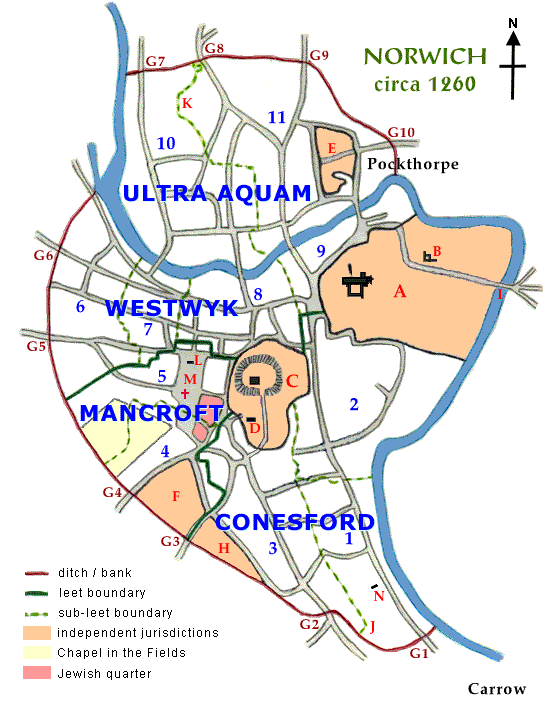