
Encyclopedia | Library | Reference | Teaching | General | Links | About ORB | HOME
 History of
medieval Norwich
History of
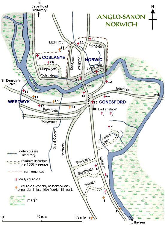
medieval Norwich| Sketch-map of Anglo-Saxon Norwich |
 |
KEY TO CHURCHES: T.R.E. – in the time of Edward the Confessor T.R.W. – in the time of William the Conqueror
The earliest reference to this that I have come across is a city document relating to the foundation of the cathedral, but itself dating no later than 1297. Even this refers to it as the palace of Roger Bigot, earl at the time of the cathedral foundation, and gives only an approximate location on Tombland. The cathedral register itself makes no reference to a palace in its account of its foundation. However, there was evidently a local tradition to this effect, accepted by Norwich historians such as Blomefield and Hudson. It is not implausible that the ealdorman/earl of Anglo-Saxon times had a residence in the chief town of East Anglia; Tombland would be the logical spot for such. St. Benedict's Gates An area on either side of which was the later site of St. Benedict's Gates, perhaps extending north to the later Heigham Gate (a lesser gate, near the south bank of the river), appears to have been one of the earliest foci of settlement, preceding Westwyk; archaeology has found here locally-made Ipswich ware and imported pottery dating from the 9th century. Perhaps this was the precursor from which Westwyk developed after an influx of Danish settlers on the eastern side (i.e. in the gap between the St. Benedict's Gates settlement and Conesford). Merholt The name means "boundary wood" or possibly "wood by the marsh". Hudson thought this referred to the point to which marshland extended in early Saxon times, but it may possibly relate to the extent of the settlement north of the river, as later defined by the burh fortification. Alternatively it might be a reference to the extent of the hundred of Taverham. Great Cockey The word "cockey" is of Saxon derivation, meaning simply a watercourse. Some were later called "fleets". The Great Cockey was the largest of these various streams (only a few of which are shown on my map), penetrating farther into the city than the others, and is freqently mentioned as a boundary in property deeds. For much of the Saxon period it was probably fairly wide and marshy, perhaps acting as a separator between Westwyk and Conesford. Tombland As the meeting-point of two major roads, the possible meeting-place (folkmoot) of the community, with at least one important church (St. Michael de Motestow) and the (hypothetical) "Earl's palace" on its outskirts, Tombland is generally assumed to have been the centre of the Anglo-Saxon town and – given that the land remained largely unbuilt on – perhaps the marketplace. Possibly part of the land may have had an association with St. Michael, although "tomb" does not refer to a burial-ground but means "vacant". However, Tombland was not the property of the community but of one of the town's lords; and it was the earl who gave it to the Bishop to expand the developing cathedral-priory precint. The Bishop pulled down church and palace; and the monks thereafter claimed rights on Tombland which became a source of dispute between them and the citizens. Holmstrete The "street" termination suggests an early and possibly Roman origin, by contrast with the "gate" termination which was Danish. The name refers to the Cowholm – the riverside meadow used as pasturage – through which the road ran to reach a ford across the river (later the site of Bishop's Bridge). The section immediately east of Tombland was supplanted by the cathedral precinct, and the road diverted north of that; the section further east, however, retained the name Holmstrete during part of the Middle Ages. Despite the diversion, Holmstrete continued to serve as the main route out of the city towards more easterly regions. Berstrete The "street" termination suggests an early and possibly Roman origin, by contrast with the "gate" termination which was Danish. That this road was atop a ridge equally suggests its origin at a time when lower ground, to the east, was marshy and impassable. The northern end was subsequently covered by the Norman castle fee; in the late 18th century, workmen sinking a well in the castle grounds were said to have come across the site of this part of the road. This was primarily a road into the city; the lack of early churches along its route suggests it was not heavily settled in Saxon times. Southgate The southern stretch of what was known as Conesford Street, or Upper Conesford Street, for much of the post-Conquest period was also called Southgate (while the northern stretch had the alias of Parmentergate). Settlement in the late Saxon period lay along Conesford Street and between Southgate and Berstrete. Southgate probably represents an area of riverfront settlement providing quayage for boats without them having to travel further upriver to Fybridge. It has been debated how heavily this southern part of the city was occupied before the Conquest. However, the fact that the new Norman settlement was located west of the castle, rather than south of it along the riverside, may itself indicate there was insufficient unoccupied land along Southgate. Sandgate/Skeythgate/Holgate These secondary roads evidence a spread of population between Southgate and Berstrete. Bearing in mind that this was a steep slope, down which rainwater would have rushed, the antiquarian Kirkpatrick interpreted "Holgate" as meaning a hollow route created by erosion from rainwater. This is supported by the fact that Skeythgate was on occasion referred to as a cava via ("hollowed-out route"); its name may derive from a Saxon term referring to a steep descent. St. Faith's Lane The road leading to St. Vedast's (gradually corrupted into St. Faith's) was also known as Lower Conesford Street. Pottergate Likely represents a line of later expansion of settlement upslope from the main road (to its north) running through Westwyk, perhaps not occurring until the end of the Saxon period. Westwyk Street's early origin is itself indicated by the clustering of churches; the western end of the street later split (see map for ca.1260), as land was reclaimed from the marsh, with a fork (Lower Westwyk) running close to the river's edge. The name Pottergate reflects the early industry of pottery-making that archaeology has evidenced in Westwyk. However, the earliest pottery remains found there are from the late Saxon period. The road probably stretched west only as far as a cockey (a source of water being important to potters); when the city wall was built, no gate was created for Pottergate, so it may still not have extended as far as the wall then. Hosyergate This road represents an even later phase of expansion, as settlement continued to spread south. It likely pre-dated the introduction of the castle (the later line of the road being clearly diverted around the fee) and Mancroft, where archaeology has recently shown that Norman settlement was preceded by Late Saxon – and just possibly Norse – settlement; after the foundation of Mancroft, the western part of the road was known as Lower Newport, while the section between Mancroft and the castle was called Hosyergate. Based on the line of Lower Newport, it seems that Hosyergate would not have extended as far as the line of the later city walls, but only as far as one of the cockeys, which perhaps represented an earlier boundary line. After that cockey, Lower Newport diverts south to meet Upper Newport, the road on the southern boundary of Mancroft, which is unlikely to have existed until after Mancroft was created. The introduction of Mancroft and the castle having significantly disrupted the topography of the Anglo-Saxon town, the application of Hosyergate to the entire stretch of this east-west route is only hypothesis, based on the "gate" termination suggesting some antiquity (in contrast to other names assigned to portions of the street in the later Middle Ages, which are all clearly post-Conquest). Fybriggate The fact that this road alone incorporates "bridge" (other than the later connecting road of Neubriggate, running over what was evidently an additional, or "new", bridge), indicates that the Fye Bridge was the first to be built across the Norwich stretch of the Wensum. Whether the bridge existed pre-Conquest or was simply preceded by a ford or causeway, is less easy to say. Snailgate/Cowgate The line of the burh defences, suggested by archaeological evidence, along with the "gate" termination, argues for the existence of these roads in the late Saxon period. It was common for there to be access routes around the inner edge of the defensive perimeter of the burh. Archaeological evidence for a cluster of habitation around the southern end of Cowgate and St. Edmund's and around St. Martin's in north-east Conesford argue for a linkage via a second river crossing on the future site of Whitefriars Bridge (and again, the line of the burh defences encourages the notion of protecting two river crossings). Fishergate/Colegate The "gate" termination betokens a pre-Conquest date (although we cannot rule out the possibility of the Danish naming protocol having survived the Conquest for a period). The two roads represent riverside settlement. However, they did not quite meet up, St. Clement's and its surrounding land interposing between them. They cannot be seen as a single development, but two areas of separate development, each joining up with Fybriggate. It would be reasonable to associate the name Fishergate with the quayside where fishing-boats would have docked; a logical place for the fishermen to live. This was probably one of the more built-up residential streets north of the river. One possible derivation of the name Colgate is from an Anglo-Saxon term for lake (see below re. Muspolgate). Muspolgate Named after the Muspol, a small lake fed by a cockey. Hudson suspected that at an early time the north-south route at the western edge of Coslanye (itself named Coslanye Street) may have met up with Colgate only via Muspolgate, because of the extreme marshiness of the ground in the bend of the river, of which Muspol represented a shrunken survival. I do not myself subscribe to this theory; it would have been more logical for the line of Muspolgate to have continued east or south-east to Snailgate rather than swing directly south again. Muspolgate has more the appearance, from later topography, of a secondary route from the rear of St. Mary's; its junction with Colegate was later diverted when St. George's church was built there. |
| Created: December 3, 1998. Last update: December 24, 2000 | © Stephen Alsford, 1998-2003 |
|
Encyclopedia | Library | Reference | Teaching | General | Links | Search | About ORB | HOME The contents of ORB are copyright © 2003 Kathryn M. Talarico except as otherwise indicated herein. |