
Encyclopedia | Library | Reference | Teaching | General | Links | About ORB | HOME
 History of
medieval Yarmouth
History of
medieval Yarmouth| Yarmouth at the close of the Middle Ages |
| NOTES: | |
|
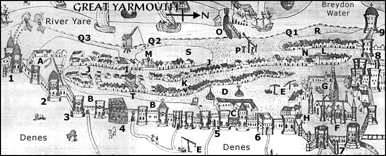
This is in fact part of a larger plan showing Yarmouth and its surrounds
in the time of Queen Elizabeth I. In most of its details it
well reflects how Yarmouth must have looked at the close of the fifteenth
century, although there are of course post-medieval features. This plan
is presented to give a general sense of the appearance of the town, but
should not be trusted for accuracy.
| |
|
THE WALLS
Construction began in the 1280s and continued throughout the 13th and 14th centuries. It is generally thought that work began on the north-east portion (adjacent to St. Nicholas') and proceeded southwards. In 1337 work was underway in the vicinity of the Dominican friary. The northern stretch was perhaps the last part to be undertaken. |
|
| 1 | South Gate |
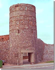
| 2 | Blackfriars Tower |
| 3 | South-east Tower |
| 4 | This appears to represent a fortification added in the post-medieval period, in response to the threat from Spain; if so, the artist has greatly truncated the stretch of wall between it and the South-east Tower. |
| 5 | Market Gate |
| 6 | Pudding Gate |
| 7 |
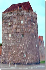
King Henry's Tower Thought to have been named after Henry III who first licenced the borough to construct walls. |
| 8 |
North
Gate Two leper-houses stood a short distance north of the gate. |
| 9 |
North-west Tower |
|
THE DENES
The Denes were an extensive beachy area on the east side of the walled
town. As can be seen from the depiction, townsmen let their animals roam
here. Also visible in the complete depiction (but not in this cropped
version) are the windmills that had been built on the Denes since the
time of Edward I, and were a source of complaint by the Cinque Ports men,
who charged that they interfered with the drying of fishing-nets (of which
an example is also shown in the complete depiction); in 1277 Edward ordered
a limitation on the number of windmills there. This right to dry
their nets there was part of the rights of "den and strond" granted the
Cinque Ports men by Henry II; the nets were hung from ships' masts. The
beach was also used as an area for building ships, while old, derelict
ships abandoned there was another source of annoyance to the Portsmen. |
|
| WITHIN THE WALLS | |
| A |
Dominican friary The Black Friars were said to have arrived in Yarmouth in 1267. They obtained licence from the king in 1271 to acquire a plot of land (referred to as being part of "La Straunde", i.e. the beach) 500' x 500' to expand a narrow strip of property already possessed at the south end of the town; on this land they had built a convent by 1273. This was subsequently extended, thanks to burgess benefactors, into a large precinct. |
| B | Dene side |
| C | St. Mary's Hospital |
| D |
Marketplace The two features on either side of the "D" appear to represent the market cross (left), which sat atop an open-sided roofed building, and the pillory (right) that were set up there in 1395, when the market was also partially paved, as a result of a pavage licence obtained from the king. |
| E | Community wells |
| F |
St. Nicholas' Church Antiquarians are divided on whether this was founded on the site of the St. Benedict's mentioned in Domesday, or superseded a chapel built two decades earlier which became a source of dispute between the Bishop of Norwich and the Cinque Ports fishermen as to who would appoint the priest. It has been suggested that the Bishop of Norwich built the church with some of the Caen stone he was importing for the construction of Norwich cathedral. It was enlarged in the mid-13th century and again in the 1330s. |
| G |
Charnel house The "Carnary" was built in the churchyard ca. 1308 through the benefaction of Sybil, widow of William Flathe. This was no easy task, since it required permission from the Bishop of Norwich, the King, and the Pope. Its purpose was to house the bones of those whose graves were dug up to make room for new inhabitants. Sybil endowed this chapel with various rents (for whose collection and application the borough government was made responsible) in order to support two priests to perform divine services for the dead. She herself died in 1311. The charnel was pulled down after the Reformation. |
| H |
Benedictine Priory This was a cell of Norwich Priory |
| I |
Tolhouse Built of flint in the 14th century |
| J |
Great Middlegate (street) The southerly portion was sometimes known as South Middlegate or even Southgate |
| K |
Little Middlegate (street) Known from the 1330s as Blind Middlegate |
| L | Northgate (street) |
| M |
Franciscan friary Established at some time in the 13th century, perhaps as early as 1226; the Gerberge family was said to have been the Grey Friars' patron. |
| N |
Carmelite friary The White Friars convent was said to have been founded ca. 1278. The various orders consumed so much of the limited space in the town that when the Augustians arrived, latecomers, they established themselves in Little Yarmouth instead and had to be satisfied with a cell in Great Yarmouth. |
| O |
Bridge to West Yarmouth The king gave the town permission in 1417 to built a bridge to replace a ferry service; it is not clear whether this was accomplished immediately or until a few years later. |
| P | Probably represents a mechanism for weighing merchandize (trone), given its central location on the quayside and near the bridge into town. |
| Q |
Quayside Since it stretched along the length of the Yare bank, sections of the quayside were distinguished from each other by their own names.
|
| R |
The Conge This was an area of the Lord's Quay. The name is possibly associated with a French term used in relation to the clearances to depart that ships' masters had to obtain from the authorities. It was perhaps here that there was a house for collection of customs (unless the Tolhouse served that function) – without payment of which, ships would not be allowed to depart. |
| S |
The Foreland An open plain for much of the Middle Ages, residences were built upon part of it during the 15th century. |
| T |
Possibly represents a building called the "Castle",
a keep-like structure, origins unknown, but mentioned as early as the
13th century and just possibly associated with the Earl of East Anglia.
During the Late Middle Ages it was in private hands; by the time it came
into the hands of the corporation, in the 16th century, it was in
decay. |
| Created: January 31, 1999. Last update: June 27, 1999 | © Stephen Alsford, 1999-2003 |
|
Encyclopedia | Library | Reference | Teaching | General | Links | Search | About ORB | HOME The contents of ORB are copyright © 2003 Kathryn M. Talarico except as otherwise indicated herein. |