
Encyclopedia | Library | Reference | Teaching | General | Links | About ORB | HOME
 It is no coincidence that the development of numerous medieval
towns owes much to their location at the intersection of land routes
and navigeable waterways. While the Romans (no lovers of maritime travel)
favoured roads, in the Early Middle Ages there was a shift in preference
towards water-based routes, which affected settlement patterns and
established the roots of many future towns. Whether a town prospered and
grew, or stagnated, depended in part upon its ability to compete with other
regional settlements as a market centre; the better its connections
to other trading centres in other parts of the country or overseas, the
more likely it was to flourish. Mobility was important to the medieval
merchant. Matthew Paris' map of Britain (mid-13th century) showed the
principal rivers as abnormally prominent features, and most of the
towns or castles on the map were located either on the coast or on one
or other of the rivers; the importance of rivers continued to be highlighted
on later maps, including the
Gough map
of mid-14th century. This importance was due not only to their
transportation role, but to roles as sources of fresh water (despite their
opposing role as sewers) and sources of power for
mills.
The River Wensum flowed
in one direction into the Yare, which in turn provided quick access to the
sea and thereby to coastal trade (and other rivers flowing into northern
Norfolk and Suffolk), to foreign ports, and to the fishing-grounds of
the North Sea. It nourished not only commerce but also excellent
meadow-lands for grazing livestock, while it and the streams that ran off
it fed corn-fields and served the development of local industries such as
(at different periods) the manufacture of pottery and the
finishing of cloth.
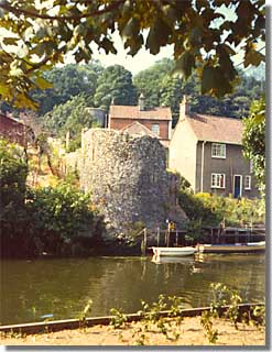
In addition the river provided an obstacle to hostile forces, making it
unnecessary to extend city walls along the southeastern stretch of the city,
where the Wensum acted as the boundary. On the other hand, for boats the
river provided an easy access through the defensive lines – too easy.
Consequently, where the river entered the city from the south, the
local authorities built, where the city walls terminated a tower on each
bank of the river (that on the west is shown here); between these were
hung "two great chains of good Spanish iron across the river with the
machines wound by a windlas in the tower on the west so that no ship nor
barge nor boat might come in or depart without leave, nor against the will
of those who have to govern the city." [Hudson
and Tingey, The Records of the City of Norwich, Norwich: Jarrold,
1910, vol.2, p.218] York was using chains for a similar purpose
on the Ouse in 1380.
It is no coincidence that the development of numerous medieval
towns owes much to their location at the intersection of land routes
and navigeable waterways. While the Romans (no lovers of maritime travel)
favoured roads, in the Early Middle Ages there was a shift in preference
towards water-based routes, which affected settlement patterns and
established the roots of many future towns. Whether a town prospered and
grew, or stagnated, depended in part upon its ability to compete with other
regional settlements as a market centre; the better its connections
to other trading centres in other parts of the country or overseas, the
more likely it was to flourish. Mobility was important to the medieval
merchant. Matthew Paris' map of Britain (mid-13th century) showed the
principal rivers as abnormally prominent features, and most of the
towns or castles on the map were located either on the coast or on one
or other of the rivers; the importance of rivers continued to be highlighted
on later maps, including the
Gough map
of mid-14th century. This importance was due not only to their
transportation role, but to roles as sources of fresh water (despite their
opposing role as sewers) and sources of power for
mills.
The River Wensum flowed
in one direction into the Yare, which in turn provided quick access to the
sea and thereby to coastal trade (and other rivers flowing into northern
Norfolk and Suffolk), to foreign ports, and to the fishing-grounds of
the North Sea. It nourished not only commerce but also excellent
meadow-lands for grazing livestock, while it and the streams that ran off
it fed corn-fields and served the development of local industries such as
(at different periods) the manufacture of pottery and the
finishing of cloth.
In addition the river provided an obstacle to hostile forces, making it
unnecessary to extend city walls along the southeastern stretch of the city,
where the Wensum acted as the boundary. On the other hand, for boats the
river provided an easy access through the defensive lines – too easy.
Consequently, where the river entered the city from the south, the
local authorities built, where the city walls terminated a tower on each
bank of the river (that on the west is shown here); between these were
hung "two great chains of good Spanish iron across the river with the
machines wound by a windlas in the tower on the west so that no ship nor
barge nor boat might come in or depart without leave, nor against the will
of those who have to govern the city." [Hudson
and Tingey, The Records of the City of Norwich, Norwich: Jarrold,
1910, vol.2, p.218] York was using chains for a similar purpose
on the Ouse in 1380.
|
Encyclopedia | Library | Reference | Teaching | General | Links | Search | About ORB | HOME The contents of ORB are copyright © 2003 Kathryn M. Talarico except as otherwise indicated herein. |